
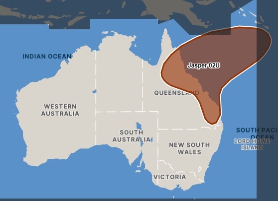
Tropical Cyclone Jasper has been upgraded to a category 3 system and is expected to strengthen further as it moves towards the Queensland coast.
Jasper is forecast to reach high end category 4 intensity later on Thursday and possibly category 5 on Thursday night, the Bureau of Meteorology said in its latest forecast.
Over the weekend Jasper is likely to weaken but will remain as a tropical cyclone next week.
🌀Severe Tropical Cyclone Jasper remains well offshore of the QLD coast this morning, moving slowly towards the southwest. Significant uncertainty remains about the track beyond the weekend and any impacts on QLD. Stay up to date: https://t.co/YTkwbdYNGp pic.twitter.com/fV0jFKfr7D
— Bureau of Meteorology, Queensland (@BOM_Qld) December 6, 2023
The “unusual” cyclone tracked south-southwest into the Coral Sea overnight.
“At this stage the highest risk of a cyclone impact is the region north of Mackay but the timing and severity of the coastal impact remains highly uncertain at this stage,” the bureau said.
Earlier: The Sunshine Coast is in the wide firing range of a tropical cyclone that formed in the Solomon Sea.
The system, named Jasper, was tracking south-south-west towards the Queensland coast, but it was still well out to sea, casting plenty of uncertainty over its future path.
A seven-day forecast map, issued by the Bureau of Meteorology on Tuesday evening, showed there was a high chance it could strike land anywhere between north of Cairns and the Sunshine Coast by late Tuesday next week.
There is also the possibility it won’t make it to the Queensland coast.
BOM community information officer Daniel Hayes said there was plenty of unknowns regarding the cyclone’s future.
“At this stage there is still quite a bit of uncertainty as to where it will move,” he said. “There are some potential influences from larger weather patterns around the region that may determine where it goes.”
But he said there was a chance it could affect the Sunshine Coast.
“There are a whole range of potential impacts for the Sunshine Coast, depending on exactly where it moves,” he said.
“It would probably move to north of the Sunshine Coast, if it crosses, but if it does move further south, it will depend on whether it crosses or tracks close to the coast.”
If the cyclone did track near the Sunshine Coast, the region would receive plenty of rain, strong winds and large swells.
A North Queensland crossing would have less influence on the Sunshine Coast, but it could still “contribute to increased humidity” in the area.
“And even though it may not directly impact the Sunshine Coast, it could enhance systems with shower and storm activity sometime in the next week or so,” he said.
Mr Hayes also said a North Queensland crossing could lead to seasonal swells being impacted earlier on the Sunshine Coast.
The cyclone, which was at 933 hPa late Tuesday, was expected to get significantly stronger in coming days.
“It’s going to intensity quite quickly and should be Category 4 by the end of the week,” Mr Hayes said.
At that level, it would have a maximum wind speed of 160-199km/h, with gusts of up to 225-279km/h.
Australia’s tropical cyclone season runs from November 1 to April 30.
There is likely to be a below-average number of tropical cyclones for the 2023-24 season (76 per cent chance of less than four TCs in the eastern region), largely due to El Nino, which typically leads to drier and warmer conditions.
In El Nino years, the first cyclone to make landfall on the Australian coast typically occurs later than normal, in January.
The last cyclone to make its presence significantly felt on the Sunshine Coast was Seth, which crossed the coast near Hervey Bay as a sub-tropical low, bringing strong winds and large waves, in January 2022.
Debbie, which crossed the North Queensland coast and weakened, before making its way south, brought powerful winds and heavy rainfall in March 2017.
Help keep independent and fair Sunshine Coast news coming by subscribing to our FREE daily news feed. All it requires is your name and email at the bottom of this article.
