
The Sunshine Coast has seen its fair share of change over the past decade or so.
From large-scale housing developments to major infrastructure projects to environmental shifts, the Coast has transformed into a bustling hub that’s home to about 330,000 people.
Now, thanks to the wonders of aerial imagery, we can bring you a visual record of those changes over the years.
Sunshine Coast News has partnered with Australian location intelligence company Nearmap to bring readers a series of interactive photos showing how the Coast has changed. Simply drag the slider across the photos to compare the different years.
Sunshine Coast Airport
Aerial imagery by Nearmap
The new Sunshine Coast Airport runway was delivered by Sunshine Coast Council in June 2020. These photos compare December 2012 and May 2023.
University of the Sunshine Coast
Aerial imagery by Nearmap
Since opening in 1996 with 524 students, UniSC has continued to grow and now has more than 17,000 students. These images, from January 2010 to May 2023, show the development of state-of-the-art learning facilities and a world-class sports precinct.
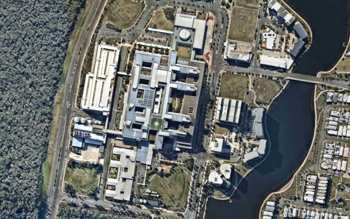
Sunshine Coast University Hospital
Aerial imagery by Nearmap
SCUH opened at Birtinya in 2017. The project took about four years and cost $1.8 billion. These images span exactly 10 years, up to May 2023.
Caloundra Road interchange
Aerial imagery by Nearmap
The $932 million upgrade to widen the Bruce Highway to six lanes between Caloundra Road and the Sunshine Motorway was officially declared complete in September 2021. These images show the changes from July 2010 to May 2023.
Sunshine Coast Stadium
Aerial imagery by Nearmap
The Coast’s main sporting hub has changed drastically since this first image was taken in January 2010, and the changes won’t stop there. Details have been revealed for a new world-class indoor sports centre and expanded stadium at the precinct in Kawana, ahead of the Brisbane 2032 Olympic and Paralympic Games.
New Maroochydore CBD
Aerial imagery by Nearmap
The former Horton Park Golf Club closed in 2015 after being offered $42 million in compensation by Sunshine Coast Council to relocate to make way for the new CBD. Work has steadily progressed since then, with the $100m City Hall opening in December 2022. The area is part of an emerging city heart that will play a key role in the 2032 Olympics, with plans to include a 1374-bed Olympic Village. These images are from September 2015 and May 2023.
Housing developments
Several masterplanned estates have been in development on the Coast in recent years, helping to grow the population by more than 79,000 people from 2011 to 2021, according to council figures. That population is forecast to grow to more than 500,000 people by 2041.
Harmony, Palmview: February 2017 – May 2023
Aerial imagery by Nearmap
Sunshine Cove, Maroochydore: January 2010 – May 2023
Aerial imagery by Nearmap
Aura, Nirimba: July 2018 – May 2023
Aerial imagery by Nearmap
Aura, Baringa: May 2016 – May 2023
Aerial imagery by Nearmap
Parklakes, Bli Bli: July 2010 – May 2023
Aerial imagery by Nearmap
Peregian Springs: January 2010 – May 2023
Aerial imagery by Nearmap
Town centres
Like the rest of the region, our main town centres have seen varying degrees of change as well. While the shifts might not be as dramatic as in some areas of the Coast, the signs of development are still evident.
Nambour: January 2010 – May 2023
Aerial imagery by Nearmap
Caloundra: January 2010 – May 2023
Aerial imagery by Nearmap
Noosa Heads: July 2010 – May 2023
Aerial imagery by Nearmap
Mooloolaba: January 2010 – May 2023
Aerial imagery by Nearmap
Coolum: April 2013 – May 2023
Aerial imagery by Nearmap
The aerial imagery in this story is from Australian location intelligence company Nearmap. The company provides government organisations, architectural, construction and engineering firms, and other companies, with easy, instant access to high-resolution aerial imagery, city-scale 3D content, artificial intelligence data sets, and geospatial tools to assist with urban planning, monitoring and development projects in Australia, New Zealand and North America.