
A master plan for the future development of land surrounding the Sunshine Coast Airport has been submitted to the state government for assessment, with a terminal expansion among the key goals.
The proposed Gateway Precinct Master Plan outlines a mix of hotels, shops, offices, industry and transport upgrades designed to cement the airport as a key driver of regional growth.
It is the first submission to be made under the Sunshine Coast Airport Priority Development Area (PDA) Development Scheme, which came into effect in September 2024.
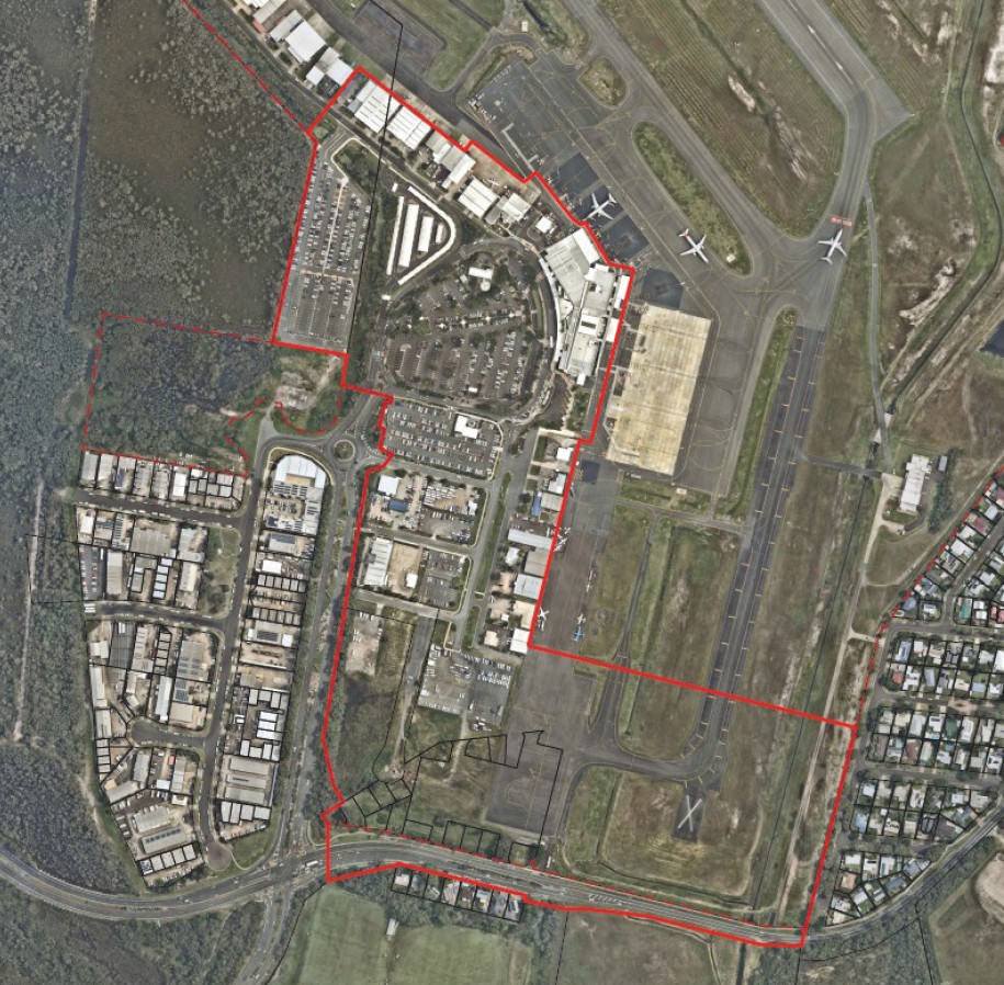
The proposed master plan covers Precinct 2 of the PDA, known as the Gateway Precinct, which includes 30 hectares around the current terminal between Airport Drive and David Low Way.
“The Gateway Precinct represents the largest opportunity for commercial and airport-related uses, and is key to unlocking operational efficiencies for the airport and its future expansion,” a report on the master plan by RPS on behalf of Sunshine Coast Airport Pty Ltd states.
“The precinct will be anchored by the airport terminal, a transit hotel and a mixed-use development, with the master plan emphasising strong, comfortable pedestrian pathways connecting these key elements.”
The master plan, which includes five sub-precincts, aims to establish parameters for subsequent development applications in the precinct by defining the land use pattern and scale of development.
Key proposals include a 250-room ‘transit’ hotel, 1500sqm ‘limited line’ supermarket, specialty retail and restaurants, service station, commercial hub, health services, childcare centre and low-impact industry to support airport operations.
Building heights would be capped at 10 storeys.
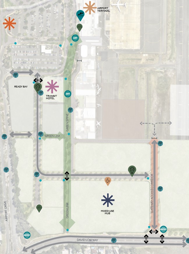
Significant transport upgrades also form part of the proposal, including a new Gateway Access Corridor that would intersect with David Low Way.
“The intersection requires straightening and realignment of David Low Way between the existing intersection to the west and the residential area to the east,” the report says. “This realignment will necessitate additional land from both SCA and Sunshine Coast Council to accommodate the changes.”
Expanded parking requirements would see the relocation of the airport control tower, and realignment of Airport Drive, with a multi-level car park planned for delivery by 2035.
Maps show a potential future public transport facility located next to the Sunshine Motorway to the west of the airport.
“The transit station, including The Wave Metro, is to be located within Gateway north area,” the report says. “The final location, access and supporting infrastructure is yet to be determined and will have an impact on the delivery and staging of the car parking.”
The five sub-precincts within the Gateway Precinct Master Plan are: Airport Operations and Services (13,500sqm), which primarily includes the existing terminal, car parking and control tower; Airport Operations and Tourism (8050sqm), which will be centred on the 250-bed hotel plus specialty retail, restaurants, car rental and other tourism-related airport services; Commercial (14,750sqm), which will establish a hub for offices, aviation-related education, healthcare, industry and other airport uses; Retail Mixed Use (7890sqm), which will provide the supermarket, food outlets, service station, car wash, childcare centre, indoor recreation and health services; and Industry (21,500sqm), which will accommodate low-impact airport-related industry, storage, research, technology, freight and logistics.
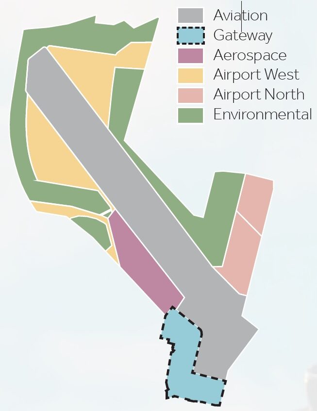
The Gateway Precinct is one of six precincts under the airport PDA. Precincts 1 and 3 would be largely used for airport operations, while Precincts 4 and 6 would be left for environmental purposes.
Precinct 5, dubbed Airport North, which adjoins existing homes at Marcoola, is earmarked for uses including short-term accommodation, a food and drink outlet, shops and offices, tourist activity, low-impact industry, indoor sport and recreation, warehouse and showroom.
The report says the terminal expansion, known as Project Horizon, is the “first significant expansion” for the airport and is expected to be operational towards the end of 2027.
The master plan also focuses on enhancing the ‘public realm’ through careful design elements, This includes three key plazas and a central ‘green spine’ running north-south to David Low Way with a three-metre-wide pathway flanked by landscaping.
Economic Development Queensland, which is responsible for assessments in declared PDAs, on August 12 acknowledged receipt of the application, which was made on August 1.
If approved the plan would have a minimum currency period of 10 years.
Related story: ‘Better located elsewhere’: draft airport scheme scrutinised
The aerial imagery in this story is from Australian location intelligence company Nearmap. The company provides government organisations, architectural, construction and engineering firms, and other companies, with easy, instant access to high-resolution aerial imagery, city-scale 3D content, artificial intelligence data sets, and geospatial tools to assist with urban planning, monitoring and development projects in Australia, New Zealand and North America.
