100% Locally Owned, Independent and Free

100% Locally Owned, Independent and Free

Grab an umbrella and hang on to your hat, Seth's not done with yet!

Do you have a news tip? Click here to send to our news team.

Police target youth behaviour in coastal suburbs

Police are increasing high-visibility patrols and weapon detection efforts to tackle youth antisocial behaviour in two neighbouring areas of the Sunshine Coast. Officers have been More

Terraced seawall starts to take shape, first section to open soon

A new seawall at a Sunshine Coast main beach is coming together, with the first section expected to open before winter. Construction of the wall More

‘High risk’: Bruce Highway rated state’s worst road

The Bruce Highway is the state’s most dangerous road, according to new data. The study, which analysed speed camera activity and government crash data, gives More

Drones to take wildlife rescue to new heights

The acquisition of drones is expected to help a local conservation group's wildlife rescue efforts. The equipment, made possible by Unitywater’s Healthy and Thriving Community Grants More

New e-scooter laws to hit state parliament

The state government will introduce sweeping new e-mobility laws to parliament this week, accepting all 28 recommendations from a parliamentary inquiry aimed at improving More

Developments fuelling rise in injured wildlife, say rescuers

Wildlife rescuers on the Sunshine Coast have reported a surge in injured and displaced animals as housing development spreads across the region. Susanne Scheuter and More

The remnants of Ex-Tropical Cyclone Seth are expected to result in heavy rainfall in our region.

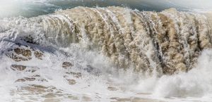
While weakening dramatically, the once-powerful system isn’t completely done with, and will create strong winds and rough seas into the weekend.

It also could dump a parting gift of up to 100mm of rain on the Sunshine Coast region on Friday.

The Bureau of Meteorology is also predicting the chance of thunderstorm.

The seas are expected to be wild for a few days.

A strong wind warning also will be in place with winds possibly exceeding 30 knots.

The swell will be 2m to 2.5m, but the waves will blown apart by the onshore winds.

The BOM says a ridge extending from a high pressure system near New Zealand will extend along the southern coast in the wake of ex-tropical cyclone Seth.

Saturday is looking better with only a 50 per cent chance of showers and winds turning east to northeast and easing to 15-20 knots.

Sunday will be partly cloudy and then there’s only the chance of a shower or two through to Wednesday.

Temperatures over the next few days will be between 22C and 27C.

For more information, go to bom.gov.au.


Subscribe to SCN’s free daily news email

This field is for validation purposes and should be left unchanged.
This field is hidden when viewing the form
[scn_go_back_button] Return Home
Share