
A design concept has been created for more upgrades to an intersection labelled “suicide hill” by one local.
The junction of Ninderry Road and Elouera Drive, on a crest and bend, could receive a range of extra safety measures after officials re-examined the area.
The area was upgraded in recent years with enhanced line marking, new signage, reflector guideposts, vegetation clearing and yellow line marking.
But residents launched a petition last year calling for further action.
Local Kerry McLean said blind spots put drivers and pedestrians at risk, describing the junction as “Russian roulette” and “unnerving and stressful.”
“Many locals call it suicide hill,” she added.

Recent correspondence between Sunshine Coast Council and Ms McLean indicates the intersection is now in line for more substantial upgrades.
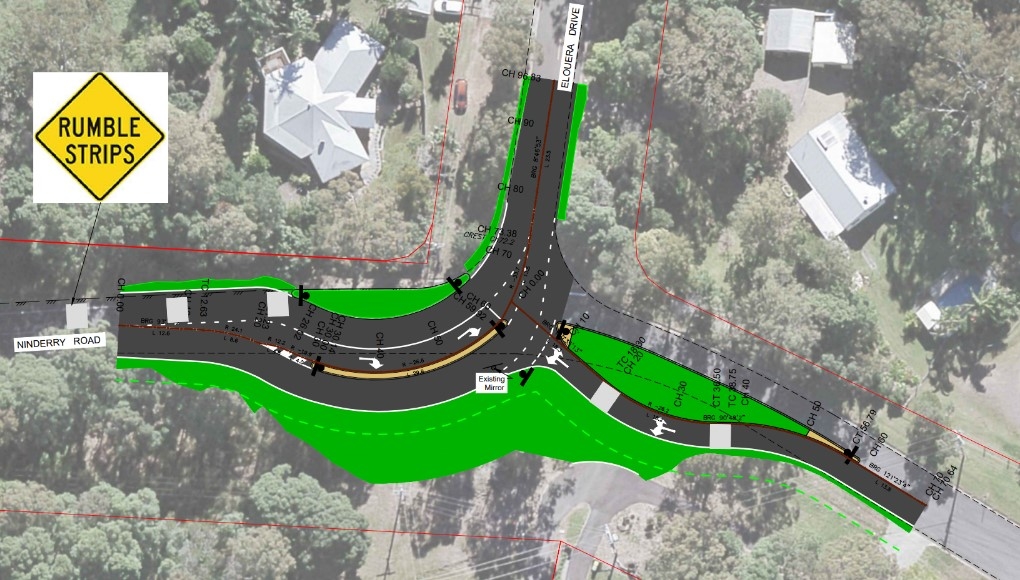
The council letter stated that the project has been re-prioritised and a design concept developed, including earthworks, new pavement, kerb and channel and concrete medians to designate a right-turn lane.
The communication also stated that the council is investigating the possibility of a federal grant through the Black Spot program to share costs, and the council’s Transport Capital Works team has nominated capital funding in the 2028–29 budget to complete the design.
Sunshine Coast News asked the council for more details but was told further information will be provided once funding is confirmed and detailed design work begins.
The released concept design shows a new right-turn lane on Ninderry Road, rumble strips, median strips, large shoulders and kerbs, and road realignments to slow traffic.
“Seems we might be getting our intersection fixed,” Ms McLean said.
“Fingers crossed.”
Scroll down to SUBSCRIBE for our FREE news feed, direct to your inbox daily.
About 1145 vehicles travel through the junction daily.
A council spokesperson said last year that number “does not currently meet thresholds for major intervention under council’s risk-based prioritisation framework”, but added that further work could be carried out because of the junction’s distinctiveness.
“We recognise that local conditions, such as the intersection’s location on a crest and bend, present unique challenges,” the spokesperson said.
Mayor Rosanna Natoli also met with concerned locals before she was elected in 2024.
The aerial imagery in this story is from Australian location intelligence company Nearmap. The company provides government organisations, architectural, construction and engineering firms, and other companies, with easy, instant access to high-resolution aerial imagery, city-scale 3D content, artificial intelligence data sets, and geospatial tools to assist with urban planning, monitoring and development projects in Australia, New Zealand and North America.
