
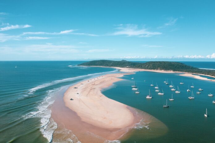
Timelapse aerial photos have captured striking changes at a scenic headland over the years.
The images, from 1985 until 2023, show the dramatic shifts at Double Island Point: a favourite destination for four-wheel-drive enthusiasts and campers within the Cooloola Recreation Area in the Great Sandy National Park.
University of the Sunshine Coast Associate Professor Javier Leon said the timelapse showed sediment being transported from south to north and around the point – a process called headland bypassing.
“The sand spits that form over the years are very dynamic,” he said.
“Sometimes, they are shorter or more segmented and sometimes they extend and fully merge with the shoreline to form an enclosed lagoon. It depends on the sequencing of waves driving the sand around the headland.
“Extrapolating from what we know about Noosa Headland, large southerly waves will push the sediment up and large easterly waves will drive it around.
For more local news videos SUBSCRIBE to our YouTube channel. Just click here.
“The ephemeral lagoon depends on the movement of sand. Also, waves and currents change depending on the form of the spit.”
June 2018 to June 2023
Imagery courtesy of Google Earth, Maxar Technologies and CNES/Airbus.
Plenty of motorists have been caught out by the shifting sands and tides at Double Island Point.
“The movement of sand determines when and if the beach is accessible for tourism and 4WD motorists,” he said. “The lagoon, when open and deep enough, is also used by boats and fishing.
“The positioning of the spit can also influence how waves break and can increase/decrease erosion between Rainbow Beach and Double Island Point.”
Mr Leon, a geographer who specialises in coastal systems, said there could be some more significant changes on the way.
“The current forecasts show a counterclockwise rotation in the wave climate in the coming decades,” he said.
“That means that we should expect more waves coming from the east and less from the south and south-east, and less sand will be available to bypass the headland, potentially increasing erosion between Rainbow Beach and Double Island Point.”
May 2012 to May 2017
Imagery courtesy of Google Earth, GeoEye, Maxar Technologies and CNES/Airbus.
A spokesperson for the Department of Environment, Tourism, Science and Innovation said the area was continually changing.
“Queensland is renowned for our incredible natural environment including our famous beaches,” they said.
“Beaches have ongoing impacts due to natural processes like high tides and storms.”
The spokesperson urged motorists to take care.
“If you’re planning to drive on the beach it’s important to keep a few safety tips in mind. The best time is at low tide or within two hours either side of it, as this provides the safest conditions,” they said.
“When driving, take it slow and steady, and ensure everyone is wearing a seatbelt.
“Beach driving follows the same rules as road driving, so all road rules apply. This means your vehicle must be registered, and you’ll need a valid licence to drive.”
For more see driving on sand and driving on sand safety guide.
All imagery courtesy of Google Earth. Map data copyright of Landsat/Copernicus, Maxar Technologies, GeoEye and CNES/Airbus.