
The owner of a riverfront property on the edge of a popular tourist town is appealing a decision to refuse her retrospective application for earthworks on the block.
Gmelli Design Pty Ltd is appealing to the Planning and Environment Court after Sunshine Coast Council rejected its application for operational works at 32-40 Elizabeth Street, Kenilworth.
The council said the works would pose “extreme and unacceptable risk to life and property” and “alter the natural floodway of the Mary River”.
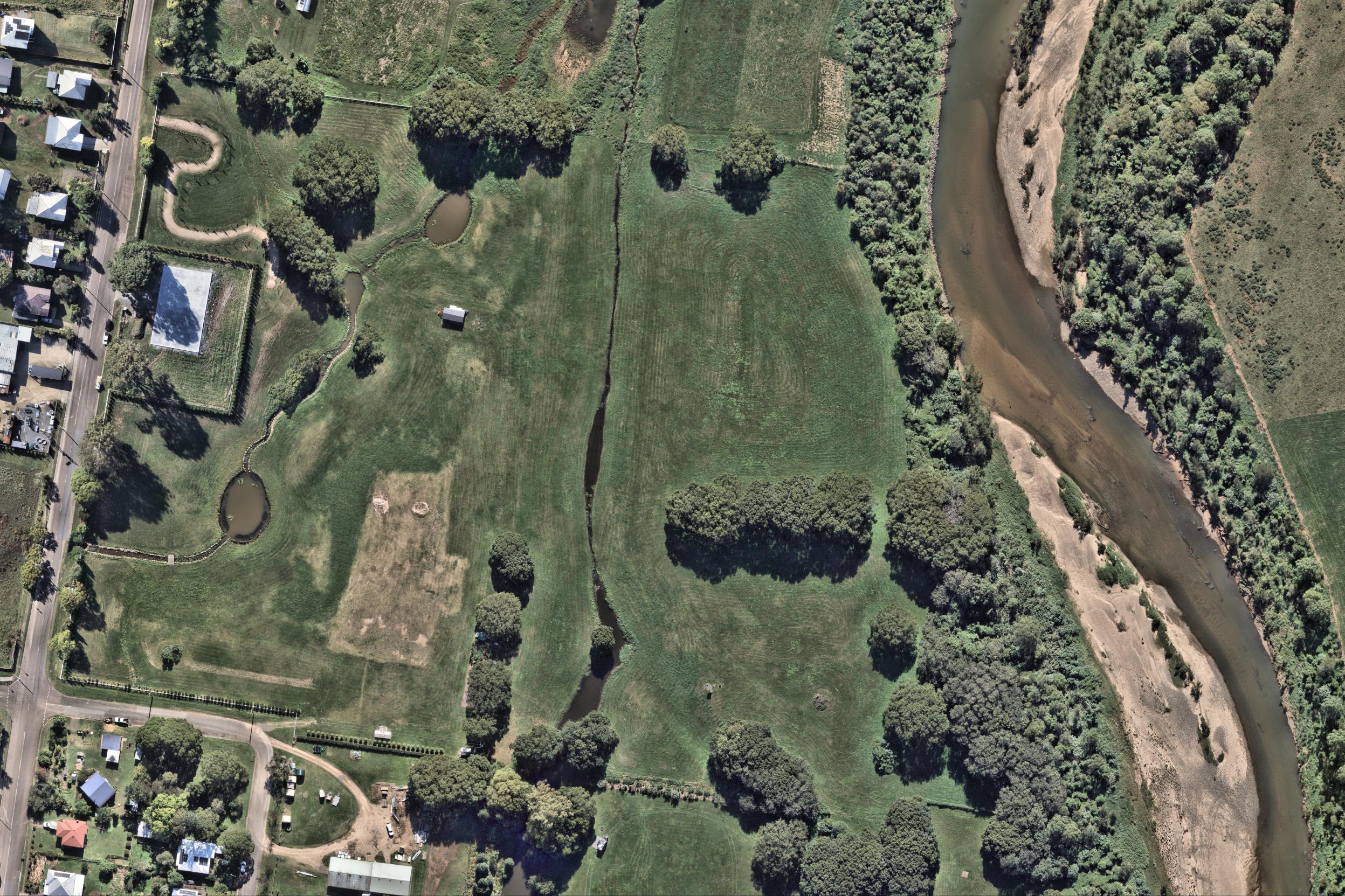
The 9.2 hectares of currently vacant rural land has two mapped waterways, including the Mary River to the east.
The application was lodged in response to a show cause notice given to the owner of the land, Gmelli Design’s sole director Kristy Giumelli, by the council in September 2023.
Ms Giumelli is an interior designer with a strong presence on social media.
The show cause notice alleged unlawful earthworks comprising more than 50 cubic metres of earthworks within a flood hazard overlay had been undertaken without permission.
The development application, submitted in November 2023 and subject to code assessment, sought retrospective approval for the earthworks, which involved filling for a level building pad and minor cut to widen and formalise the existing mapped waterway. It involved a total of 192 cubic metres of cut and 3532 cubic metres of fill.
Correspondence involving information requests and responses between the applicant and council, as well as the State Assessment and Referral Agency, continued from December 2023 until May 2025.
On June 24 the council issued a decision notice advising it had refused the application, with Gmelli Design launching the court appeal on July 22.
“The development application ought to be approved subject to lawful conditions,” the appeal stated.
“Even if the proposed development does not comply with some of the assessment benchmarks, which is not admitted, compliance with the assessment benchmarks can be achieved by imposing development conditions.”
The council’s reasons for refusal include concerns about flood risks, impacts on the waterways and ground instability.
“The proposed development fails to mitigate risk to an ‘acceptable or tolerable level’,” it said. “It will result in future occupants located in an area of ‘high flood risk’ with potential flood depths of 14 metres during a PMF (probable maximum flood), which is an extreme and unacceptable risk to life and property.
“The proposed development actively hinders ‘disaster management responses’. The only evacuation route is severed by almost four metres of water in a DFL (defined flood level) event, making safe evacuation impossible and trapping residents.
“(It) alters the natural floodway of the Mary River and fails to provide compensatory flood storage or assess the cumulative hydraulic impacts of the fill, thereby adversely impacting the function of the floodplain.
“The proposed placement of a significant volume of uncontrolled and uncompacted fill creates an unmitigated risk of instability. The applicant’s own geotechnical report identifies risks of saturation and erosion preventing development that is stable in the long term.”
The development application submitted in November 2023 provides more detail about the plans for the property.
“The level building pad comprises an area of approximately 3660sqm and results in a change to ground level of 1.69m at its highest point,” it stated.
“The development site is located within the flood hazard overlay area and the building pad has been provided to accommodate a future dwelling house and associated outbuildings/structures that is capable of achieving flood immunity. The building pad is located approximately a minimum 32m from the nearest property boundary.
“Cut has occurred along the mapped waterway with the waterway being widened to approximately 3m and a depth of 1m. The works also involved rock lining the waterway with large natural sandstone to formalise waterway location and improve maintenance capabilities.”
No hearing dates have been set.
The aerial imagery in this story is from Australian location intelligence company Nearmap. The company provides government organisations, architectural, construction and engineering firms, and other companies, with easy, instant access to high-resolution aerial imagery, city-scale 3D content, artificial intelligence data sets, and geospatial tools to assist with urban planning, monitoring and development projects in Australia, New Zealand and North America.
