
Sunshine Coast residents are on edge as Tropical Cyclone Alfred exerts its influence on South-East Queensland and northern New South Wales.
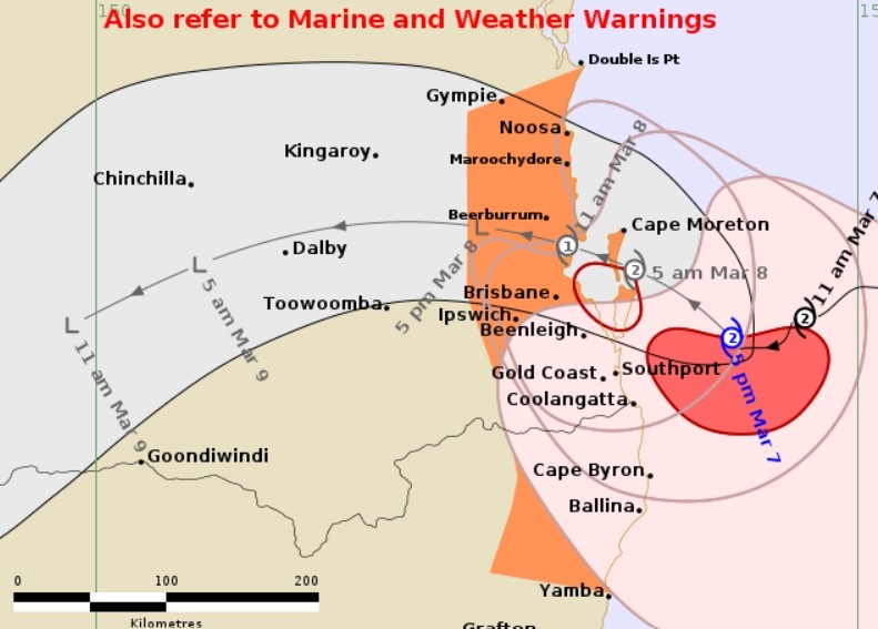
The Bureau of Meteorology issued a warning late Friday for Double Island Point to Yamba, amid expectations the system could cross the coast between Noosa and Beenleigh on Saturday afternoon, which is later than anticipated.
Areas near and to the south of the cyclone’s centre were set to bear the brunt of the wild conditions and many communities either side of the border had already been subjected to damaging wind and rainfall.
The Sunshine Coast was predicted to feel some effects of TC Alfred, including wind gusts up to 130km/h, heavy rain that could lead to flash flooding, storm surges that could cause flooding in low-lying areas, and potential power outages.
Residents have been urged to stay at home, police have door-knocked more than 1600 local homes at risk of flooding, emergency refuge centres have been established, and more than 230,000 sandbags have been collected.
Schools have been cancelled, public transport services suspended and flights impacted. Retailers around the region, including major supermarkets, have shut their doors.
Beaches have been closed and a maritime red zone has been established but emergency services have still had to come to the rescue of jet skiers and swimmers.
There was blue sky above the Sunshine Coast late Friday afternoon, but Sunshine Coast Council urged people to stay indoors and off the roads from 6pm.
Sunshine Coast Mayor and Local Disaster Management Group chair Rosanna Natoli said the region was at risk.
“Now is not the time to be complacent,” she said.
“The BOM is expecting Tropical Cyclone Alfred to make landfall Saturday.
“We’re expecting to experience potentially destructive winds (from Friday night).
“The strong winds could bring down trees, powerlines, blow roofs off and turn loose items outdoors into projectiles.
“Saturday and Sunday pose the highest risk for heavy rainfall and flash flooding.
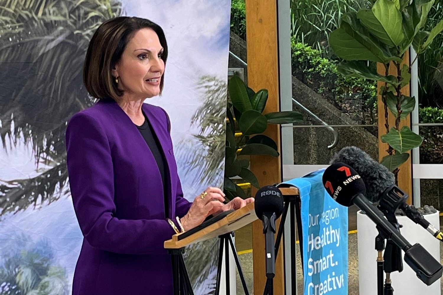
“Driving during these conditions is dangerous and flooded roads can be deadly.
“By staying indoors from 6pm (on Friday), you keep yourself, your loved ones and your community safe.
”Staying indoors also means our emergency services can focus on providing support to our most impacted.”
Want more free local news? Follow Sunshine Coast News on Facebook, LinkedIn and Instagram, and sign up for our FREE daily news email.
The cyclone was Category 2 on Friday but expected to be downgraded to Category 1 before landfall.
Bureau of Meteorology community information officer Daniel Hayes said significant rainfall could loiter after the cyclone crosses the coast.
“We’re likely to see heavier showers and storms continue even as the system moves away to the west,” he said. “We could see some thunderstorms and areas of heavy falls that could produce flash flooding.”
The BOM has predicted up to 200mm during the weekend and into Monday.
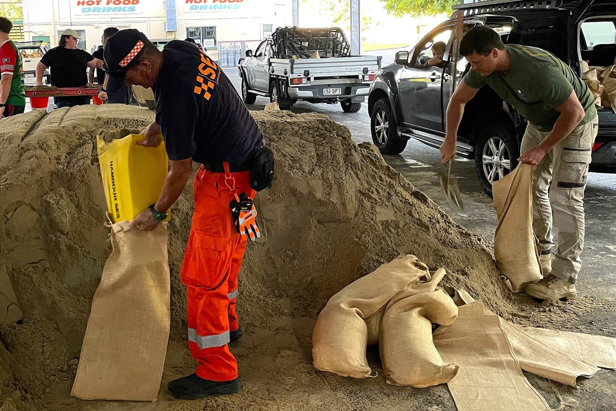
Emergency refuge centres have opened at the Nambour Showgrounds, Caloundra Indoor Stadium, Landsborough Sportsground and Noosa Leisure Centre. The former and latter are open to animals as well. Sunshine Coast sandbag depots will not be open during the weekend.
Meanwhile, $15 million in emergency assistance has been made available to south-east councils in the impact zone.
The Community Relief Fund, jointly funded by state and federal governments will provide funding to undertake essential immediate clean-up and restoration activities.
“Delivering this support now means no delay and no time between response and recovery,” Premier David Crisafulli said.
“In the wake of such devastation, it’s crucial affected communities know we have their back,” Prime Minister Albanese said.
People can report fallen trees, roads or sewerage and water infrastructure at risk via the Sunshine Coast App (the App Store or Google Play) or on 5475 7272.
Report fallen powerlines to Energex on 13 19 62.
For trees on main roads, contact the Department of Transport and Main Roads on 131 940.
Call 132500 for SES assistance and 000 in life-threatening situations.
For more information see getready.qld.gov.au, disaster.sunshinecoast.qld.gov.au (which includes flood maps) and disaster.noosa.qld.gov.au.
