

Parts of the Sunshine Coast are being walloped by hot conditions in a precursor to summer.
Temperatures rose across the region on Wednesday, amid a severe heatwave warning.
Bureau of Meteorology senior meteorologist Shane Kennedy explained why it was so warm.
“A large air mass was able to sit over western and central Australia for several days, allowing it to heat up,” he said.
“This heat is being pushed across Queensland by a trough system.
“The trough is moving east on Thursday, which will push the hot air into South-East Queensland on Thursday and Friday.”
Maximums were expected be in the mid to high-30s (five to seven degrees Celsius above average) and minimums were set to be in the low to mid-20s (two to three degrees Celsius above average) from Wednesday until Friday. There’s also the chance of some storms.
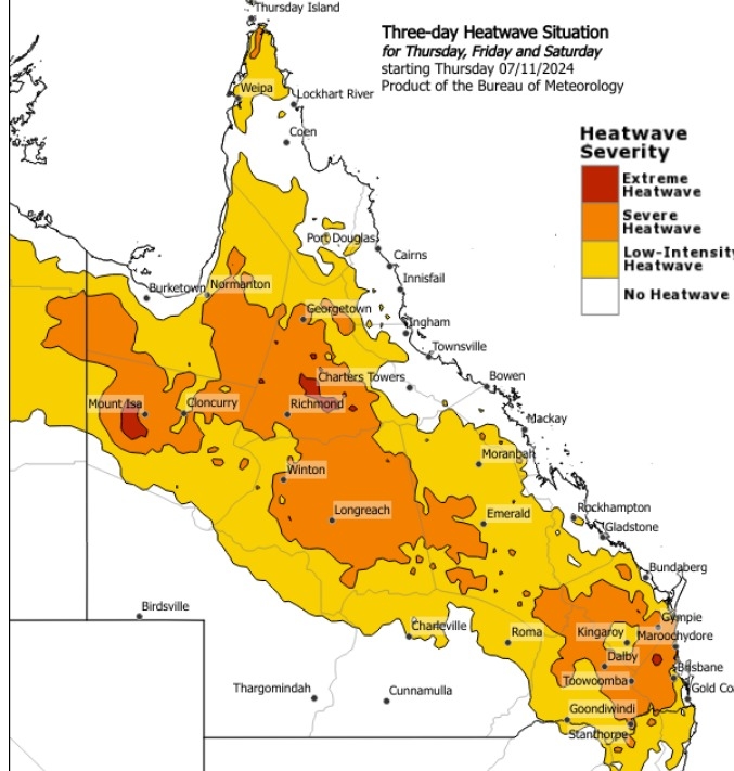
Mr Kennedy said the heatwave was rare.
“We typically see occasional hot periods in spring, particularly late spring. We had a warm spell in mid-October. But it is unusual to have such a widespread and prolonged heatwave over the state.”
He said it was a sign of things to come in summer.
“Temperatures, especially minimum temperatures, are likely to be above median for the next few months,” he said.
“This increases the chance of heatwaves for the next few months.”
But Mr Kennedy said average temperatures should return for next week at least, and it could be quite wet.
“Temperatures should fall slightly on the weekend as showers and thunderstorms increase,” he said.
“Rainfall may increase from Monday as deeper moisture builds over the south-east.
“No flooding is expected at this stage but moderate rainfall is possible.”
Heatwave know-how
- Severe heatwaves can be dangerous for many people, especially older people, babies, children, pregnant and breastfeeding women, people with medical conditions and people who are unwell.
- Seek a place to keep cool, such as your home, a library, community centre or shopping centre.
- Close your windows and draw blinds, curtains or awnings early in the day to keep the heat out of your home.
- If available, use fans or air-conditioners to keep cool.
For information on staying safe during a heatwave go to the QLD Department of Health web page.
Want more free local news? Follow Sunshine Coast News on Facebook, LinkedIn and Instagram, and sign up for our FREE daily news email.