
100% Locally Owned, Independent and Free

100% Locally Owned, Independent and Free

Cyclone Jasper set to weaken before intensifying again as it swings towards coast

Do you have a news tip? Click here to send to our news team.

Linking uni’s big ideas with business

The architect behind some of the Coast's most transformative economic development projects has taken on a new challenge with the University of the Sunshine More

Police investigate serious highway crash

Police are investigating a serious crash involving three Sunshine Coast men on the Bruce Highway. Initial enquiries indicate that just before 6.40am, a red Mitsubishi More

New deadline bid for long-running development

An eight-storey mixed-use development approved for a high-profile coastal site is the subject of another time-related application, with documents showing the project remains in More

Police appeal for help to locate girl

Police are appealing for public assistance to locate a 14-year-old girl, missing from Palmview since Sunday, July 19. The girl is described as Caucasian, about More

Contract awarded for harbour entrance improvements

A contract has been awarded to progress long-term safety and accessibility at a challenging waterway. The state government has appointed engineering consultancy BMT to undertake More

Trail steeped in history undergoes key works

A popular Sunshine Coast heritage trail has been improved so people can enjoy it for years to come. The Buderim-Palmwoods Heritage Tramway Walk received a More

Severe tropical cyclone Jasper has started to move towards the Australian coast and is tipped to make landfall in the middle of next week, bringing destructive winds and heavy rain.

As of Saturday afternoon, the category four system was in the Coral Sea about 1000km east of Cairns and had started to swing towards northern Queensland.

Earlier in the day, a rescue helicopter safely evacuated four Bureau of Meteorology scientists from a remote weather station on Willis Island in the path of the wild weather, about 450km off Cairns.
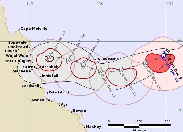
The forecast map of Tropical Cyclone Jasper’s path. Picture: Bureau of Meteorology

The cyclone is tipped to weaken to a category two system on Monday but may then intensify again on Wednesday as it approaches the coast, according to senior meteorologist Angus Hines.

He said it was likely to cross somewhere between Townsville and Cooktown but other scenarios were still possible including a crossing further north.

“Wherever Jasper crosses it will be a significant weather event likely to bring damaging to destructive winds, heavy persistent rain that will lead to flooding, a storm surge along the coast and very dangerous conditions out over the water with large waves,” Mr Hines said.

Queensland Police Acting Deputy Commissioner Shane Chelepy warned households north of Mackay to prepare their emergency kits.

The state disaster centre has moved to alert level, with local and district co-ordinators from Mackay to Cairns making preparations.

Queensland Fire and Emergency Services crews, including swift water rescue teams, are also primed to be deployed to cyclone-hit areas.

The system is the first tropical cyclone to form in Queensland waters in December in an El Nino year, which generally leads to fewer such weather events.

Want more free local news? Follow Sunshine Coast News on Facebook, LinkedIn and Instagram.

Subscribe to SCN’s free daily news email

This field is for validation purposes and should be left unchanged.
This field is hidden when viewing the form
[scn_go_back_button] Return Home
Share