After a blast of hot and stormy weather over the past week, the Sunshine Coast can expect a cooler weekend with some welcome showers.
The Bureau predicts a cloudy Thursday, with a top of 27C, and similar top Friday with the chance of a late shower.
The good news for gardeners and those trying to maintain a lawn is that Saturday and Sunday will bring a 90 per cent and 80 per cent, respectively, chance of showers.
Saturday could see falls between 8mm and 25mm and Sunday 10 to 40mm.
Severe thunderstorms dumped up to 59mm on the hinterland on Monday afternoon.
The highest rainfall totals were at Bellbird Creek near Kenilworth 59mm, Maroochydore Intake Weir near Mapleton 56 mm, Mapleton 43mm, Radar Hill 54mm and Poona Dam 52mm.
Between Maroochydore and Tewantin rainfall totals were between 20mm and 40mm, getting lighter towards Gympie.
Get more local stories direct to your inbox by subscribing to our free daily news feed: Go to SUBSCRIBE at top of this article to register
Earlier
Nearly 12,000 homes and businesses were left without power in the region on Monday evening as the weather bureau issued an alert for damaging winds, large hailstones and heavy rainfall.
The first round of storms hit the Sunshine Coast – encompassing Caloundra to Noosa – about 4.30pm and a second front later in the evening at the far southern end.
Energex reported power outages to about 22,000 properties in south-east Queensland, with the bulk on the Sunshine Coast.
The worst-affected suburbs were Maleny (2307), Nambour (1325), Maroochydore (1148), and Pacific Paradise (1037).
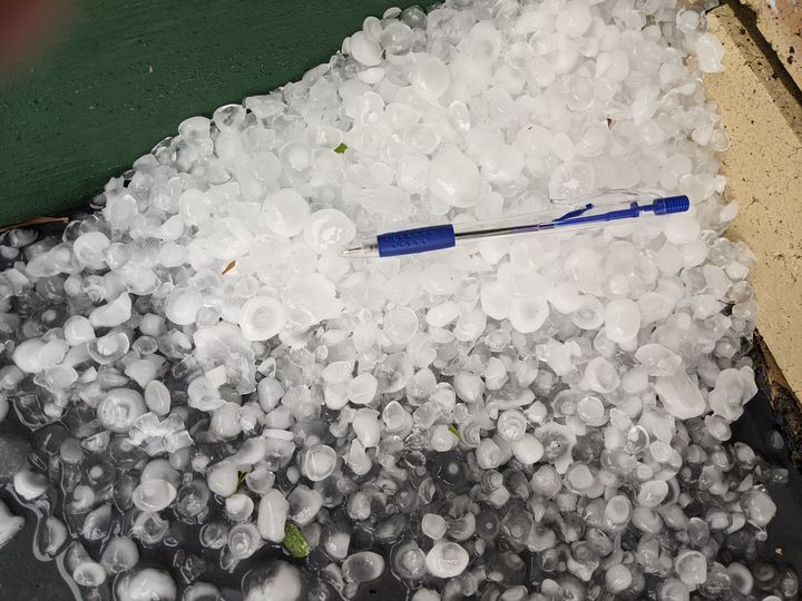
BOM forecaster Kimba Wong said there were reports of winds so strong they had knocked over shipping containers in Bongaree at Bribie Island and dumped hailstones about 4cm wide.
There were reports of 2-3cm hail at Woodford around 1:00pm to 1:15pm and 4cm hail at Bongaree around 2:10pm.