
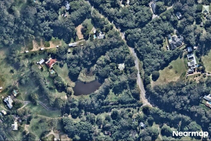
A hinterland road will be closed for about four months while major landslide damage is repaired.
Nandroya Road at Cooroy is expected to shut in early to mid-October after it was significantly damaged during severe weather in early 2025.
A Noosa Council spokesperson said the landslide had compromised the stability of the road and damaged the culvert beneath its full width.
Cooroy Area Residents Association president Rod Ritchie outlined the group’s response to the planned works.
“We understand roads often need major repairs, but disappointed that the works could not be done with one lane always available,” Mr Ritchie said.
The association said Noosa Council had not consulted it about the detour arrangements.
Mr Ritchie also said he did not believe affected residents had been given enough notice and wanted the council to provide “regular updates”.
A council spokesperson said residents on Nandroya Road and surrounding streets had been advised in August that a closure would be required and had been given detour information.
They added local businesses in Cooroy and Eumundi had also been contacted, while information had been promoted through local media and online channels.
A council spokesperson said the council had received no complaints about the detour, although there had been a few follow-up inquiries about the route, signage and timing of the works. Mr Ritchie also said the association had not received any complaints from residents thus far.
Sunshine Coast News has been provided with a “Digital Doorknock” update dated September 17 which was distributed to residents, outlining the changed construction timetable and arrangements for Nandroya Road.
The notice said crews had previously been scheduled to be on site in late September, but final traffic and environmental approvals were still in progress.
It advised residents work was instead anticipated to begin in early to mid-October and said the start date and road shutdown depended on those approvals.
The notice also stated there would be no through access during construction and acknowledged the impact on residents, businesses and motorists.
Council said it would provide further information by email as it became available and circulate updates through local newspapers, libraries and social media. Electronic traffic signs would also be installed once the date was confirmed.
The council spokesperson said changed conditions had been in place since the damage occurred while engineers and designers investigated reconstruction options.
Noosa Council CEO Larry Sengstock said the site presented several challenges, including overhead powerlines, underground services and an embankment about 8m above the creek.
“Council also investigated alternative options, including upgrading Martins Road as a temporary traffic route and constructing a temporary bridge across the landslide area,” Mr Sengstock said.
“However, these options were not considered viable due to cost, environmental impacts, constructability and site constraints.
“A temporary road closure was determined to be the safest option for both road users and construction workers and will deliver the best outcome in terms of construction time, cost and environmental impact.
“While we acknowledge the closure will be inconvenient, it will allow the works to be completed as efficiently as possible.”
Do you have an opinion to share? Submit a Letter to the Editor at Sunshine Coast News via news@sunshinecoastnews.com.au. You must include your name and suburb.
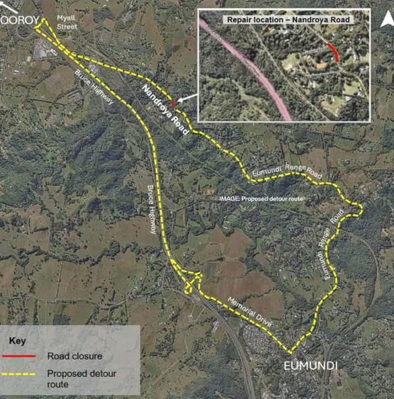
Council’s detour information in the residents’ notification shows motorists travelling from Cooroy to Eumundi will be directed via Myall Street, the Bruce Highway and Memorial Drive.
Those travelling from Eumundi to Cooroy will use Eumundi Range Road, Memorial Drive and the Bruce Highway.
“The approved detour route has been assessed for safety and may add up to 15 minutes to some journeys, depending on origin and destination,” Mr Sengstock said.
Mr Sengstock said the council had been liaising with emergency services, bus operators and waste collection providers for several months, with further service information to be provided closer to the works.
“We acknowledge and apologise for the inconvenience this will cause residents and the wider community.
“Council has provided regular updates to residents since the damage occurred and first flagged the possibility of a road closure earlier this year.”
Council said it would continue to keep the community informed as the works approached.
The aerial imagery in this story is from Australian location intelligence company Nearmap. The company provides government organisations, architectural, construction and engineering firms, and other companies, with easy, instant access to high-resolution aerial imagery, city-scale 3D content, artificial intelligence data sets, and geospatial tools to assist with urban planning, monitoring and development projects in Australia, New Zealand and North America.